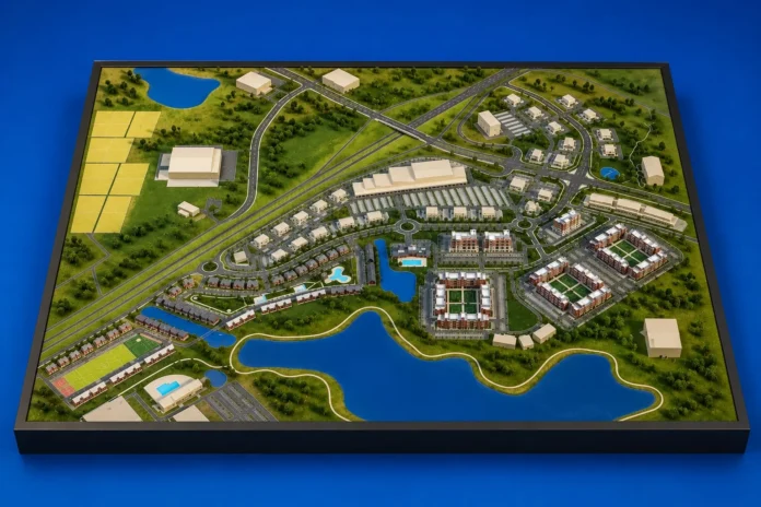

Drive through almost any Indian city today and you’ll notice the same things: a stretch of road that didn’t exist three years ago, a cluster of cranes where an empty plot used to be, a metro pillar rising in the middle of traffic. Growth is happening in layers, and tracking it on paper is getting harder. That’s one reason master plan model making India has quietly turned into a steady line of work, serving everyone from government agencies to private developers who need to explain what a place will look like years before it exists.
The models themselves aren’t new. What has changed is who wants them, how detailed they’ve become, and how much they’re expected to do besides sit under a glass cover.
Cities are changing faster than drawings can explain
A master plan is a heavy document by nature. It carries land-use zones, road hierarchies, utility corridors, open space, density norms and phasing. On a screen or in a bound report it’s accurate but abstract. Decision-makers who aren’t planners by training tend to skim it, and that isn’t laziness. A dense drawing simply asks a lot of anyone who hasn’t learned to read one.
A physical model does the reading for you. You see that the industrial zone sits upwind of the housing blocks, that the main road crosses the canal only once, or that the university campus is oddly cut off from the transit line. Problems that hide in a drawing become obvious the moment you stand on either side of a table.
Who actually orders these models
The customer list is wider than most people guess. Development authorities and smart city bodies use models to present proposals to elected officials and the public. Industrial park developers use them to show prospective tenants where plots, power and water will be. Universities and hospital groups build them to explain campus expansion to donors and boards. Airports, ports and special economic zones bring them into investor meetings, where one table can replace forty slides.
Private real estate remains the largest group by volume. Township launches, plotted developments and integrated mixed-use projects all rely on a model as the anchor of their sales gallery. Even smaller developers have started asking for them, since buyers now expect to see something they can touch.
From CAD file to tabletop
The path from drawing to model is more hands-on than people imagine. It starts with collecting the approved layout, contour data, landscape plans and building massing. Then the makers work out the scale, the base size and the level of detail. A large site might be built at 1:1000 to keep the table manageable, while a compact campus could go to 1:300 so that individual buildings carry proper detail.
Laser cutting and CNC work handle the repeatable elements: base layers, building blocks, road pieces. After that, people take over. Edges get sanded, buildings assembled, trees planted, water bodies poured or layered in acrylic, and surfaces painted to reflect the materials actually planned. Lighting circuits go in last, and testing them tends to reveal small wiring problems that would embarrass everyone if found on launch day.
Terrain, scale and the details that make a model believable
Flat models look like toys. Real land has slope, and even a gentle gradient changes how a project reads. Contour-built bases, where each layer represents a fixed elevation, help viewers understand drainage, views and retaining structures. This matters especially for hill towns, riverfront projects and coastal developments.
Scale is the other decision that shapes everything. Too small, and buildings turn into anonymous blocks. Too large, and the model won’t fit through a door, let alone a showroom. A sensible approach is to choose the smallest scale at which the important details, such as tower numbers, entry gates and pedestrian routes, stay readable at arm’s length.
Small human touches count too. Trees in slightly different sizes, cars parked at odd angles, a few street lamps that actually glow. None of this is decoration for its own sake. They give the eye something to compare against, and that’s what makes the sense of size land properly.
Why physical models still matter in a digital era
There’s an obvious question here. With walkthrough animations, drone renders and virtual reality all available, why build anything at all? The short answer is that screens control attention. Someone else decides where the camera goes. A model lets six people look at six different corners at the same time and argue about them, which is what real planning meetings look like.
There’s also a psychological effect that’s hard to copy digitally. People remember what they’ve physically stood around. A chairman who leaned over a model during a review will recall the layout weeks later. The same person may not remember a slide.
That said, the best projects combine both. Digital tools handle early study and iteration, while the model becomes the shared reference once the layout settles. Some models even include projected light effects so that growth phases can be shown on the same physical surface.
Practical tips for anyone commissioning a model
If you’re thinking about master plan model making India for your own project, a few habits will save you money and stress. Freeze the layout before work starts, because changing a road alignment halfway through means cutting new pieces. Decide where the model will live. One designed for a showroom is built differently from one that has to travel to exhibitions and fit inside a crate.
Ask for a sample section or material, not only photographs. A small test piece tells you more about finishing quality than any portfolio. Be clear about updates too. If the plan will evolve in phases, ask whether sections can be replaced without rebuilding the entire base.
And build in time. Rushed models show it, usually in the paintwork and the lighting. Two or three review points along the way, where your team checks progress photographs against the approved plan, are far better than one big surprise at the end.
Closing thoughts
As Indian cities keep stretching outwards and upwards, the need to explain complex plans clearly isn’t going away. Firms working in this space sit somewhere between craft, engineering and communication, and the best of them understand that a model succeeds when a non-expert can grasp the whole project in a few minutes.
If you’re weighing your options, take a look at how specialists approach master plan model making India and judge the work by how clearly it explains a place, not by how shiny it looks in a photograph.